We regret to inform you that we have learned Laing passed away last year. He was a strong supporter of the Island Register, and he will be truly missed by all who knew him.
From a scan by Laing MacDowell "MACDOWELL, Charles Laing - Died peacefully at the Credit Valley Hospital after a short illness on June 25, 2010. Born on November 4, 1920 in Summerside, Prince Edward Island to Arthur and Melissa MacDowell. Enlisted in the Canadian Armed Forces in 1942. Predeceased by his wife Doreen Weeks from Sault Ste. Marie. Worked for the Bank of Nova Scotia as Bank Manager in Fort William, St. Thomas and Toronto until his retirement. Survived by his daughter Heather Loria of Long Island, NY and son Ross MacDowell of Kitchener, as well as four grandchildren Vincent, Colleen and Christina Loria and Cameron MacDowell. He enjoyed skating, curling and golfing. Volunteered with the CNIB, Masons, Scouting, Lakeshore Rehab and the Bank of Nova Scotia Pensioners club. Active on his computer composing poetry, researching genealogy and keeping in contact with many friends and family across Canada via email. In lieu of flowers, memorial contributions can be made to a charity of one's choice. Luncheon to be held at Amica Retirement Home at 4620 Kimbermount Avenue, Mississauga on July 14th from 12 until 3 p.m. Visitation at Ridley's Funeral Home at 3080 Lakeshore Boulevard West, Toronto on July 15th from 12 until 2 p.m."
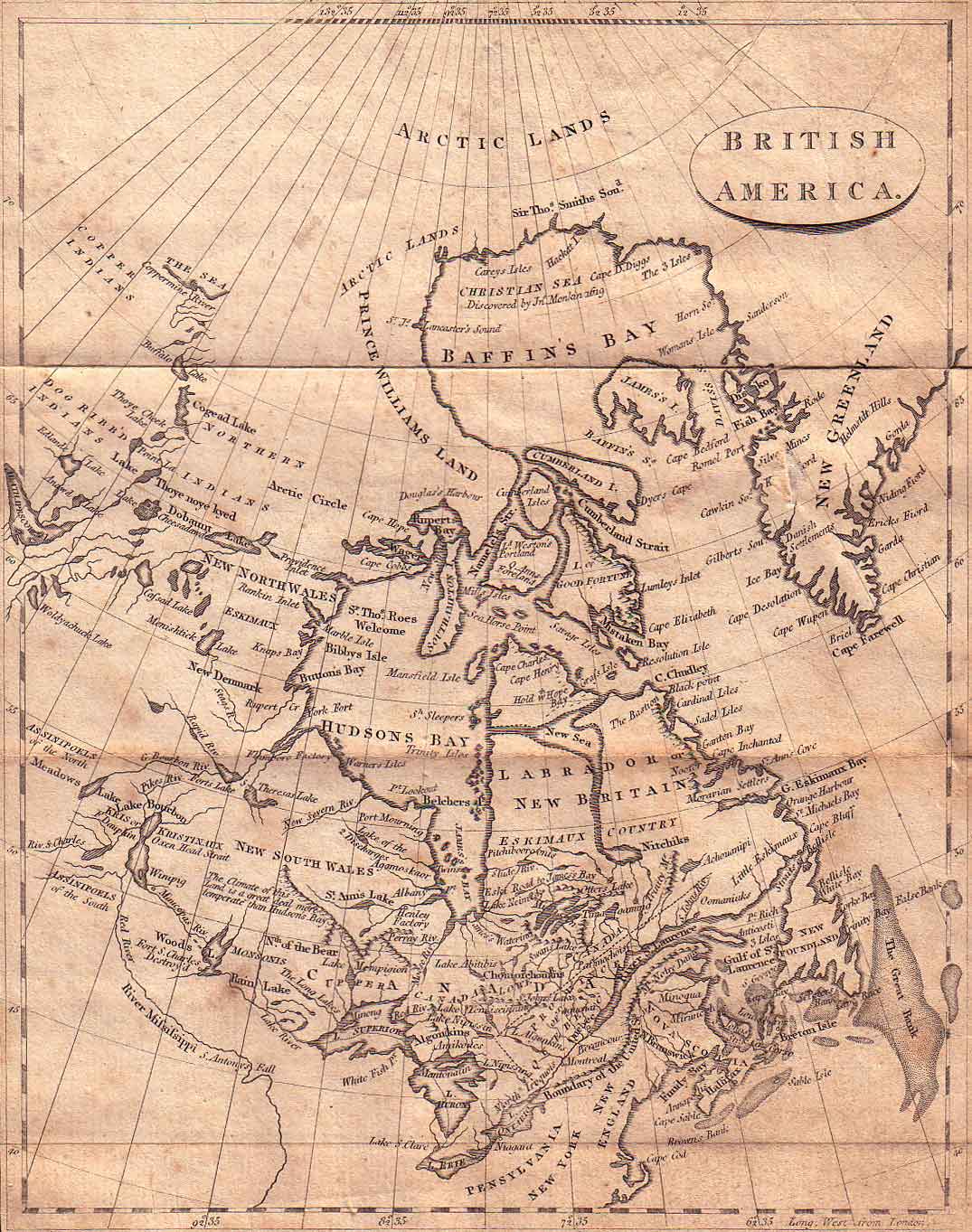
Published in the Toronto Star from July 9 to July 10, 2010The following map is from a book, ca. 1800 in the possession of Laing. It is a history of the then known world. Unfortunately the book's name, exact date, and author are unknown, as the first several pages are missing. [We have since found the title of the book is A New Geographical, Historical, and Commercial Grammar and Present State of the Kingdoms of the World" and that it was written by William Guthrie, London, 1801. Thanks to Dr. John Banham for this information] While there is no section specifically on St. John's Island, later known as Prince Edward Island, in the book, there is a section on neighbouring Nova Scotia which you should find interesting. I have included the Nova Scotia passage in the hopes that we can identify the exact title of the book, as well as its author and exact date of publication. Below the text, you will find links to view index for the book, so that you will know what areas are covered by it, and so that if any of those areas are of interest to you, you can contact Laing for further information.
Click on the image below to view full size:
From the book:
[Pgs. 865-867]
NOVA SCOTIA
Situation and Extent
Boundaries.] Bounded by the River St. Lawrence on the North; by the Gulf of St. Lawrence, and the Atlantic Ocean, East; by the �ame ocean, South; and by Canada and New England, West. In the yeat 1784, this province was divided into two governments & the province and government now �tyled New Brunswick , is bounded on the we�tward of the irver St. Croix, by the said river to its �ource, and by a line drawn due south from thence to the �outhern boundary of the Province of Quebec, to the northward by the �ame boundary as far as the we�tern extremity of the Bay de Chaleur, to the eastward by the �ame bay to the Gulf of St. Lawrence to the bay called Bay Verte, to the �outh by a line in the center of the Bay of Fundy, from the river St. Croix afore�aid, to the mouth of the Mu�quat River, by the �aid river to its �ource, and from thence by a due ea�t line acro�s the isthmus into the Bay Verte, to join the ea�tern lot above described, including all i�lands within six leagues of the coa�t.
Rivers.] The River of St. Lawrence forms the northern boundary. The rivers Ri�gouche and Nipi�guit run from Ea�t to We�f, and fall into the bay of St. Lawrence. The rivers of St. John, Pa��amagnadi, Penob�cot, and St. Croix, which run from North to South, fall into Fundy Bay, or the �ea a little to the ea�tward of it.
Seas, Bays, and Capes.] The �eas adjoining to it are, the Atlantic ocean, Fundy Bay, and the gulf of St. Lawrence. The le��er bays are Chignecto and Green Bay upon the isthmus, which joins the north part of the Nova Scotia to the �outh; and the bay of Chaleurs on the north-ea�t; the bay of Chedibucto on the �outh ea�t; the bay of the islands, the ports of Bart, Chebucto, Pro�per, St. Margaret, La Heve, port Maltois, port Ry�ignol, port Verte, and port Joly, on the �outh; port La Tour, on the �outh-ea�t; port St. Mary, Annapolis, and Minas, on the �outh side of Fundy Bay, and port Ro�eway, now the most populous of all.
The chief capes are, Cape Portage, Ecoumenac, Tourmentin, Cape Port and Epis, on the Ea�t. Cape Forgeri, and Cape Canceau, on the �outh-ea�t. Cape Blanco, Cape Vert, Cape Theodore, Cape Dore, Cape Le Heve, and Cape Negro, on the �outh. Cape Sable and Cape Fourche on the �outh-we�t.
Lakes.] The lakes are very numerous, but have not yet received particular names.
Climate.] The climate of this Country, though within the temperate zone, has been found rather unfavorable to European con�titutions. They are wrapt up in the gloom of a fog during great part of the year, and for four or five months it is inten�ely cold. But though the cold in winter and the heat in �ummer are great, they come on gradually, �o as to prepare the body for enduring both.
Soil and Produce.] From �uch an unfavorable climate, little can be expected. Nova Scotia, or New Scotland, till lately was almo�t a continued fore�t; and agriculture, though attempted by Engli�h settler�, made little progre�s. In mo�t parts, the �oil is thin and barren, the corn it produces is of a �hrivelled kind, like rye, and the gra�s is intermixed with a cold �pongy mo�s. However, it is not uniformly bad; there are tracts in the penin�ula to the �outhward, which do not yield to the be�t land in New England, and by the indu�try and exertions of the loyalists from the other provinces, are now cultivated, and likely to be fertile and flouri�hing. In general, the �oil is adapted to the produce of hemp and flax. The timber is extremely proper for �hip-building, and produces pitch and tar. Flattering accounts have been given of the improvements making in the new �ettlement and bay of Funtly [sic]. A quantity of land hath been cleared, which abounds in timber, and �hip loads of good ma�ts and �pars have been �hipped from thence already.
Animals.] This country is not deficient in the animal productions of the neighbouring provinces, particularily deer, beavers, and otters. Wild foul� and all manner of game, and many kinds of European fowls and quadrupeds have, from time to time been brought into it, and thrive well. At the clo�e of March, the fi�h begin to �pawn, when they enter the rivers in �uch �hoals, as are incredible. Herrings come up in April, and the �turgeon and �almon in May. But the mo�t valuable appendage of New Scotland is the Cape Sable coa�t, along which is one continues range of cod fi�hing-banks, navigable rivers, ba�ons, and excellent harbours.
History, Settlement, Chief Towns, and Harbours.] Notwith�tanding the forbidding appearance of this country, it was here that �ome of the �ir�t European �ettlements were made. The fir�t grant in lands, in it was given by James I to his �ecretary Sir William Alexander from whom it had the name of Nova Scotia, or New Scotland. Since then, it has frequently changed hands, from one private proprietor to another, and from the French to the Engli�h nation backward and forward. It was not confirmed to the Engli�h, till the peace of Ultrect, and their de�ign in acquiring it does not �eem to have �o much ari�en from any pro�pect of direct profit to be obtained from it, a� from an apprehen�ion that the French, by po��e��ing this province, might have had it in their power to annoy our other �ettlements. Upon this principle, 3000 families were tran�ported in 1749, at the charge of the government into this country. The town they erected is called Halifax, from the earl of that name, to who�e wi�dom and care we owe this �ettlement. The town of Halifax �tands on Chebucto Bay, very commodiou�ly �ituated for the fi�hery, and has a communications with mo�t parts of the province, either by land carriage, the �ea, or navigable rivers, with a fine harbour, where a �mall �quadron of �hips of war lies during the winter, and in �ummer puts to �ea, under the command of a commodore, for the protection of the fi�hery, and to �ee that the articles of the late peace, relative thereto, are duly ob�erved by the French. The town has an intrenchment, and is �trengthened with forts of timber. The other towns of le�s note are Annapolis Royal, which �tands on the ea�t �ide of the Bay of Fundy, and though but a �mall place, was formerly the capitol of the province. It has one of the fine�t harbours in America, capable of containing a thou�and ve��els at anchor, in the utmo�t �ecurity. St. John's is a new �ettlement, at the mouth of the river by that name, that falls into the Bay of Fundy, on the we�t �ide.
Since the conclu�ion of the American war, the emigration of loyali�ts to this province from the United States, hath been very great, by them new towns have been rai�ed, as Shelbourne, which extends two miles on the water �ide, and is �aid to contain already 9000 inhabitants. Of the old �ettlements, the mo�t flouri�hing and populous are Halifax, and the townships of Wind�or, Norton, and Cornwallis, between Halifax and Annapolis. Of the new �ettlements, the mo�t important are Shelbourne, Parr town, Digby, and New Edinburgh. Large tracts of land have been lately cultivated, and the province is now likely to advance in population and fertility."
Note: If anyone recognizes this text, and can give me the full name of the publication, its author, and date of publication, please contact me!The following links will take you to images of the book's index, so that you can see what is included. Use your browser's "Back" button to return from each image. If you wish any more information on sections outside of the Maritimes, please email Laing at the address displayed at the top of this page:
[ Index Page 1 | Index Page 2 ]