At the beginning of the American War of Independance, in 1783, Holland was sent to Quebec, where he remained until his death. His wife (second spouse, his first wife, Gertrude Hasse never accompanied him to America), Marie Josette (Rolette) Holland returned to the Island from Quebec following his death, and she settled at the home of her first-born son, John Frederick Holland (b. winter of 1764�65 at Observation (Holland) Cove, St. John's Island/PEI). View "The Descendants of Samuel Holland". Marie died in 1825, and was buried in the Tryon United Church cemetery.
Perhaps no one man affected the history of the Island as much as did Samuel Holland. He was a brilliant and productive surveyor for the times, and his survey, which set out the Island in its lots, still a very large part of its mapping to this day. It was an excellent example of the skill of Holland, and typical of his work. He was a scientific man, author of many of his own innovations in surveying and cartography, and during his survey here, he put to use instruments, newly developed in Britain, such as the astronomical clock and the refracting telescope to produce an accuracy in his work, unknown before him.
A number of years ago, we had surveyors come to survey our property, and while conducting their work, they told me that they still find Holland's work amazingly accurate, compared to other surveyors of the time, especially considering the limited equipment available to him. His measurements rarely need any correction - a man set apart from his contemparies by his skill and accuracy. There can be no greater memorial than to be admired by his peers still, two hundred years from the date of his death.
December 28th, 2001 was the two hundredth anniversary of the death of Capt. Samuel Johannes Holland, surveyor/cartographer, and Surveyor General of British North America, - the man who mapped the Island, and who laid out its lots and parishes between the years of 1764 and 1766. He died in 1801, and was buried in Quebec City. During his lifetime, he accomplished mapping along the St. Lawrence River, in P.E.I., the Madelaine Islands, and Cape Breton, and south along the Atlantic coast. He began his Island mapping at Fort Amherst (now widely known as Holland Cove) in October 1764, completing his PEI mapping two years later. See article, "Campbell's History of Prince Edward Island", beginning on page 2.. His payment was to be awarded Lot 28 (Tryon area) during the 1767 land lottery. The lot was settled by a few farmers and disbanded soldiers and Samuel went on to other commissions, administering the lot as an absentee landlord. By 1798, there were 136 residents on the lot.
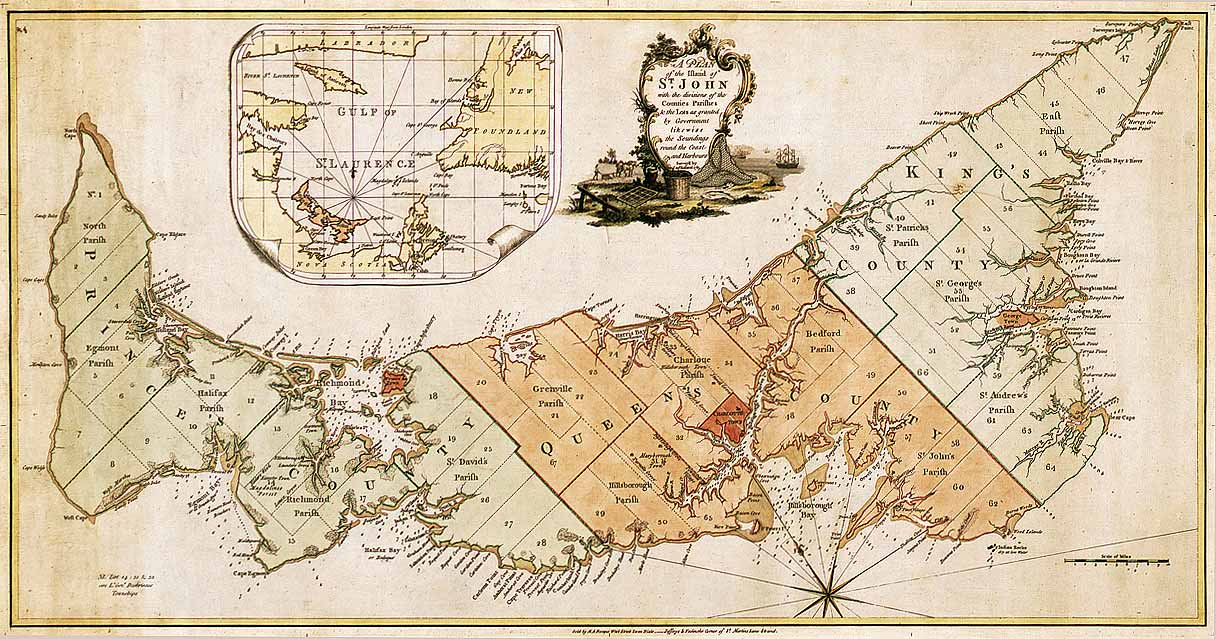
Samuel Holland's 1765 Survey and Map of St. John's Island (Prince Edward Island) showing Proposed Lots and Parishes. 2 (National Archives of Canada NMC 23350). Click on Map for larger version...
Bibliography and Notes:
1 You will find much more information on Holland and his career in the "Dictionary of Canadian Biography", Volume 5, "Samuel Johannes Holland"2 Map courtesy of the National Map Collection of the Public Archives of Canada which holds originals of Holland�s maps as well as photocopies of many others located in the ANQ-Q; G.B., Ministry of Defence, Hydrographic Dept., Admiralty Arch. (Taunton); PRO; BL; British Museum (London); Clements Library; and Library of Congress (Washington).
3 There is a later printing of this map published in "The American Atlas", (Londres, 1776, Plate 11) by Thomas Jefferys. That version differs from the original in that it is outline only, and does not include the soundings, and it includes a listing of Lots and Proprietors, and a chart of the sizes of the lots. The original of the Jefferys map is in the Public Archives and Records Office of Prince Edward Island, and 500 reprints were done some years ago by the Association of Canadian Map Libraries (Facsimile no. 16) in cooperation with the PARO. I am fortunate enough to have number 233 of that printing in my possession.
4 For an example of the difference between Samuel Holland's work, and the work of an earlier cartographer of considerable repute, view Bellin's "Dress�e sur les Manuscrits du D�post des Cartes et Plans de la Marine - 1744". One can truly appreciate Holland's precision when you compare these two maps.